File:US Catholic Dioceses and Names.png: Difference between revisions
(From https://commons.wikimedia.org/wiki/File:US_Catholic_Dioceses_and_Names.png This is a map of all Catholic Latin-Rite dioceses in the United States. I created the map using Python and geojson.io. I used OpenStreetMap and Wikipedia data to revise diocese boundaries and plot cathedral locations. (If this use of OpenStreetMap and Wikipedia data requires that I publish the map under the CC-BY-SA license instead of the CC-BY license, please let me know.) White lines are diocesan boundaries; bl...) |
(add purge) |
||
| Line 10: | Line 10: | ||
Author Kenneth Burchfiel | Author Kenneth Burchfiel | ||
{{Purge box}} | |||
== Licencing == | == Licencing == | ||
{{CC BY-SA-4.0}} | {{CC BY-SA-4.0}} | ||
Latest revision as of 21:15, 18 October 2024
Summary
From https://commons.wikimedia.org/wiki/File:US_Catholic_Dioceses_and_Names.png
This is a map of all Catholic Latin-Rite dioceses in the United States. I created the map using Python and geojson.io. I used OpenStreetMap and Wikipedia data to revise diocese boundaries and plot cathedral locations. (If this use of OpenStreetMap and Wikipedia data requires that I publish the map under the CC-BY-SA license instead of the CC-BY license, please let me know.) White lines are diocesan boundaries; black lines are provincial boundaries; and diocese names are in white text.
An interactive version of this map can be found here: https://kburchfiel.github.io/us_diocese_mapper/revised_diocese_map.html
The project's GitHub page can be found here: https://github.com/kburchfiel/us_diocese_mapper
Author Kenneth Burchfiel
|
|
If this page has been recently modified, it may not reflect the most recent changes. Please purge this page to view the most recent changes. |
Licencing
File history
Yi efo/eka'e gwa ebo wo le nyangagi wuncin ye kamina wunga tinya nan
| Gwalagizhi | Nyangagi | Dimensions | User | Comment | |
|---|---|---|---|---|---|
| current | 21:13, 18 October 2024 | 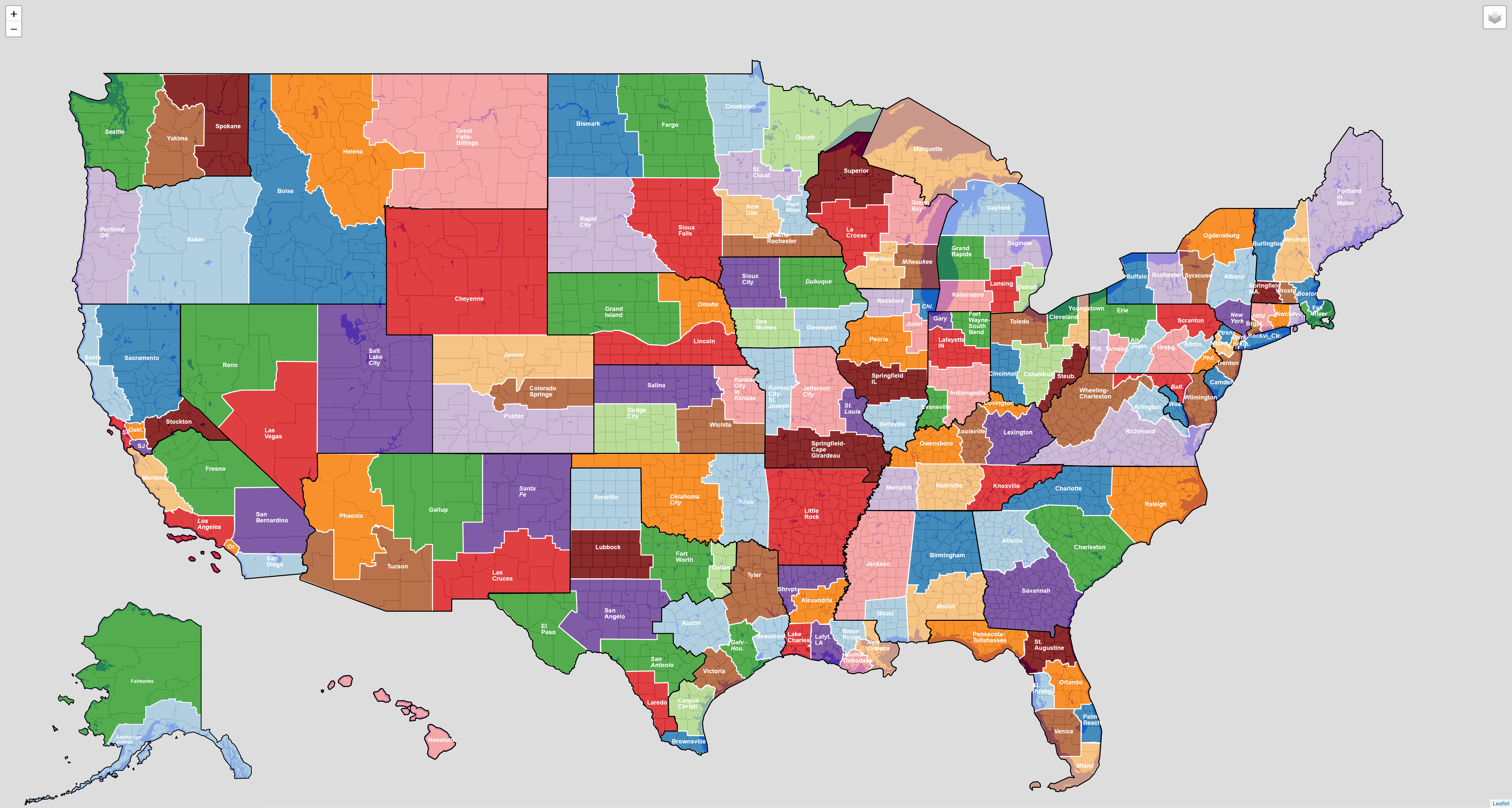 | 5,978 × 3,194 (2.64 MB) | Tom (talk | contribs) | From https://commons.wikimedia.org/wiki/File:US_Catholic_Dioceses_and_Names.png This is a map of all Catholic Latin-Rite dioceses in the United States. I created the map using Python and geojson.io. I used OpenStreetMap and Wikipedia data to revise diocese boundaries and plot cathedral locations. (If this use of OpenStreetMap and Wikipedia data requires that I publish the map under the CC-BY-SA license instead of the CC-BY license, please let me know.) White lines are diocesan boundaries; bl... |
You cannot overwrite this file.
File usage
The following 2 pages use this file: